Sunday 27 January 2019

Westeinde-Bangert 1922


The next picture postcard was sent from the hamlet of Westeinde (between Bovenkarspel and Enkhuizen) to the Bangert, another Hamlet which was particularly renowned for its beautiful orchards. As I have already mentioned in several of my previous posts about agriculture in West Frisia, the yield was in general (very) positive and because of the dawn of agricultural auctions around the turn of the 20th century farmers and (here specifically) fruit growers benefited from increased trade flows. Of course the Great Depression did harm West Frisia as well eventually, and then slowly the inevitable decline kicked in... Today the once thriving orchards of the Bangert have all but a few been erased and replaced by newly constructed neighborhoods to accommodate the ever growing city of Hoorn. Progress, as we now call it.

The journey 

Before turning to some contemporary photo's, we should pay attention to the (meager) philatelic aspects of this postcard and the route it travelled.

block-cancel
Westeinde to the Bangert 1922 
The postcard was sent by a certain W. Singer who lived in Westeinde. The addition 'Enkhuizen' tells me that he resided in the Enkhuizen part of Westeinde, rather than the Bovenkarspel area of the hamlet. Therefore I am also inclined to believe the postcard was brought to the railway station of Enkhuizen rather than the Bovenkarspel stop.

interior
Interior of the waiting room of the Enkhuizen railway station in 1941, by the looks of it 1st or 2nd class. 
You might wonder why I'm talking about the railways in the first place. Well, that's because of the quaint postmark on the Vürtheim stamp. This so-called 'Block-cancel' (Vellinga) was introduced in 1910 to cancel mail on various routes/sections of the Dutch railways. This particular postmark was used on the stretch Enkhuizen-Amsterdam. The serving postman on the train could swap the place name blocks upon arrival in Amsterdam: the name of the departing station should always be on top. This proved to be a big improvement over the older large round and typenrader postmarks where the name of the stretch was a fixed part. This particular block-cancel invalidated a 2c Vürtheim stamp which represented the rate for postal stationary in 1922. The 'C' which comes after the date might mean that this was the 3rd train departing Enkhuizen that day. The sender did presumably drop his/her card in a postbox attached to the mail wagon / 'travelling post office' in Enkhuizen or - less likely - at the Bovenkarspel stop.

block-cancel
Enkhuizen-Amsterdam block-cancel reading 31.1.22. C on a 2c Vürtheim stamp
The 31st of January 1922 had a cold touch. Without any sunshine and an average temperature of about 3°C it probably was a miserable day for many folks across the Netherlands. Periods of even colder, freezing weather preceded and proceeded the end of January.  


1922
Westeinde near Enkhuizen (top right) to the Bangert near Hoorn. 
The postcard was thus posted on a train heading west to Amsterdam, but at the rural Blokker railway station the postman in charge of the travelling post office probably unloaded several items including our postcard. At least, that's how I think the postcard was eventually delivered.   


1920
Blokker railway station, approx. 1920s 

Two agrarian hamlets - two different crop cultures


The hamlet of Westeinde between the village of Bovenkarspel and the city of Enkhuizen
When exploring the map above, you will soon realize that Westeinde (still) only consists out of one long road connecting Bovenkarspel with Enkhuizen. At the end of the 19th century two large seed cultivators from the village of Andijk moved their companies to Westeinde due to its strategic location near a city with good (rail)infrastructure. Read more about these companies here. Ever since Westeinde is known as a hub for global seed trade and since a few years the Dutch governments is eager to call this area 'Seed Valley': obviously a playful allusion to Silicon Valley. The map above shows different colours for the various types of land use. Unfortunately these colours faded a bith over time, but if you look closely you could still discern green from white. The green patches used to be pastures, whereas the white areas indicate crop fields. Nowadays almost all meadows surrounding Westeinde have vanished because of the growth of 'Seed Valley'.


Sluis and Groot Seeds at Westeinde in 1965
The destination of our postcard was home to a totally other agricultural business. I might not even call it agricultural, since it generates fruit rather than crops: fruit cultivation. The Bangert (yes, with a 'T' rather than the 'D' Singer wrote) enjoyed global attention as well. Not only because of its good-quality fruits, but foremost for its lush and majestic orchards. A Belgian teacher - Van Hulle - in agriculture visited the Bangert in 1875 and wrote in his diary: 
~ 
Around half past eleven we reached the small village of Zwaag, from which we went to visit the famous currant bushes of Bangert by foot. You would think you were in a province of China or Japan. Small, decently paved paths and small turning bridges. Plots of about 500 meters long by 20 meters wide, totally surrounded by a canal/ditch. At the front of each plot stands a house with barn and stable under one roof, the orchard begins directly behind it. In the middle (of the plot) there is a footpath with on both sides the currant bushes (each a meter apart). In between there are every 15 to 20 meters rows of 3,5 en 6 mostly apple trees, but also a lot of medlar trees and hazelnuts. Alongside the canals/ditches there grow numerous trees to be used for timber. In similar fashion there are 100s of orchards which in total comprise about 100 hectares.    
~

The foreigner was clearly impressed by the scale and neatness of the Bangert and its diversity of different fruit species. In 1875 the Bangert already belonged to one of the oldest fruit cultivation area's in the Netherlands. 'Bangert' is even derived from the Dutch Boomgaard which means orchard. Apparently people could earn proper money out of their orchards. The Enkhuizer Courant reports in 1875 that Bangert hazelnuts had sold with exceptional profits in England: up to 20 guilders per kilo. At the turn of the century some fruit grower still largely relied on the hazelnut trade. West Frisians cultivated various local fruit species such as the 'Pride of Wijdenes', 'Enkhuizer Aagje' or the 'Hoorn yellow currant'. West Frisia as a whole was by large the most important fruit cultivation area in Noord-Holland with Blokker counting 23 hectares of orchards, followed by Wijdenes with 18, Bovenkarspel with 12 and Hoorn with almost 6 hectares of fruit trees in 1880. So orchards were not only limited to the Bangert, but this area just northeast of Hoorn remained the real hotspot. In 1897 the total area of berry orchards had grown to a staggering 65 hectares!

The Bangert near the end of the 19th century. The dotted area's indicate orchards. The Blokker railway station was located at the only crossing on the excerpt near the abbreviation Stoppl. (halt).  
During the first half of the 20h century fruit cultivation remained a very profitable business even though diseases could wreck havoc. Nevertheless, after the second world war export stagnated a bit because of global competition on the fruit market. Combined with the introduction of health and safety regulations in agriculture, this proved to be the deathblow to the lavish Arcadian orchards. Standard orchards with their characteristic tall trees were not deemed safe anymore. In recent years another threat wiped out the last remnants of the once famous Bangert: housing development. Because of the rate the city of Hoorn increased in size, almost the entire area on the map above has been 'developed' now. Only the name of this new residential area reminds of the orchards now: Bangert-Oosterpolder. 

Very rare autochrome (1910s) of the Bangert with the small decorated turning bridges and modest houses as described by Van Hulle in 1875. 

Wednesday 16 January 2019

Interinsular traffic

Amsterdam
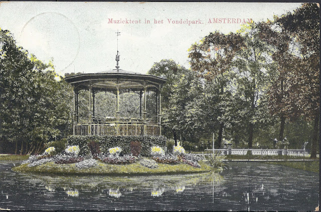
Vondelpark Amsterdam

In the Netherlands you won't easily encounter philatelists with an interest in collecting postal items which are sent to extraordinary destinations. I know that this practice is more common abroad, especially when it involves older (pre-1900) definitive series. It is really a pity that so few collectors are interested in this specific field of philately, because you could set up a very wide-ranging but specialized collection!  

The picture postcard shown above could be classified as such a 'destination piece'. I acquired it at the weekly Spui book market in Amsterdam some years ago for a bargain. I didn't purchased it out of philatelic interest, but because of the extraordinary route it ostensibly travelled: from the Dutch island of Texel to Terschelling, another island. Therefore this piece could be labelled as a genuine island-hopping postcard!


Dutch possessions Overseas

You all know, as proper philatelists, that the Dutch kingdom encompasses several islands: Aruba, Bonaire and Curaçao just north of Venezuela (of which Bonaire and Curaçao are considered sovereign countries like the Netherlands) and the smaller islands of Sint-Maarten, Sint-Eustatius and Saba which are part of the Leeuward Islands (of which Sint-Maarten is a sovereign country as well). Hence, the Dutch kingdom officially counts four countries and three 'special municipalities', viz. Bonaire, Sint-Eustatius and Saba. Therefore, it's of course wrong of me to talk about 'possessions' when three islands have to function as fully sovereign countries. In practice though these 'independent' nations are heavily dependent on the Netherlands...  The other non-independent islands from three ' special municipalities' of the Netherlands, which is quite complicated because of the sheer distance between these islands and their motherland. Sint-Maarten and Curaçao became independent states as late as 2010, formally dissolving the Netherlands Antilles and paving the way for two incapable islands regimes to take control. To nobody's surprise these new sovereign states turned corrupt...

Far from these tropical regions five other Dutch islands exist, although I guess you couldn't name them, since they have no special status whatsoever. They are relatively small and are located in the Wadden Sea, which stretches from the Netherlands to Denmark. From the Dutch city of Den Helder (Napoleon called it Europe's northern Gibraltar) to the German sea border in the east the islands are known under the following names: Texel, Vlieland, Terschelling, Ameland and Schiermonnikoog.  


Texel
Reverse of the postcard. The 1c postal stationery rate didn't allow for additional text on (picture) postcards. Addresses only! 

Now I have meticulously explained how our kingdom consists out of 4 countries, we turn to this item, sent from one Wadden Island to another, resp. Texel and Terschelling in 1909. Something you won't find everyday, especially since both islands were sparsely populated (and visited) at the time the postcard was sent. We read the the addressee is a certain miss B. Katoen, c/o Mr J. Boekholt living in the Torenstraat in West-Terschelling. 'Katoen' is Dutch for 'cotton'. The sender is a certain T. Reuvers Md.  Md. stands for Mdochter: daughter of M.    


The route travelled

The postcard could have been sent over the Frisian town of Harlingen by taking some sort of ferry. As we'll see there are many different routes to discuss.  

Option 1: Texel (left) and Terschelling (top) could have been connected by ferries services over Harlingen in 1909


De Cocksdorp in the northern part of Texel was founded (1836) by Mr De Cock from Antwerp, after two smaller islands merged together (Texel and Eierland) and the newly gained land became suitable for farming and living. In 1909 the village and surrounding area was still destitute of anything modern and by 2001 the village counted only 481 inhabitants. As most places in the Netherlands during the 19th century, daily life was uneventful and especially tranquil compared to our modern society. Life on an island however had its own particular dangers: storms threatening the fishing fleet which could deprive a town of its male population. This happened to a little town called Moddergat at the end of the 19th century: 83 fishermen died in a furious storm in the night of 5/6 March 1883. Agriculture in low-lying areas such as the Eierlandsepolder (shown on the map below) had to cope with the silt influences of the nearby sea, making it quite impossible for farmers back then to compete with products from the fresh-water and extremely fertile polders in other parts of the Netherlands. In short, people living in De Cocksdorp were more exposed to the elements than in other parts of the Netherlands. 

De Cocksdorp in the early 1930s in the northern part of Texel. At the time a very small village, living from agriculture and fishery. The red arrow points to Dorpzigt farmstead (see below). 

Our postcard arrived in a village called West-Terschelling, which is the most populated place on the entire island of Terschelling and became infamously known because the English burned the place in 1666. People still talk about this 'English fury'. As many villages on the Dutch Wadden Islands it shared many resemblances with De Cocksdorp: fish and small-scale agriculture.   

Other possible routes


De Cocksdorp
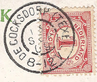
Large round postmark of De Cocksdorp (Texel),
reading 13 SEP 09 8-12V on 1c Vürtheim
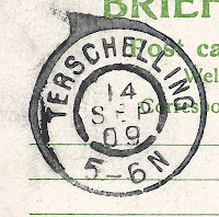
Terschelling
Large round postmark of Terschelling, reading 14 SEP 09 5-6N


The most obvious route would have been the one I have plotted above. Since both islands were part of Noord-Holland back then, and the dates on the postcard differ quite a bit (De Cocksdorp 8-12V (before noon), September 13) vs. (Terschelling 5-6N (after noon), September 14), we might also include the possibility that the postcard went all the way from De Cocksdorp to mainland Noord-Holland via Amsterdam or by the ferry Enkhuizen-Stavoren to Harlingen, where the postcard would have been shipped to Terschelling. See the map below for the Enkhuizen-Stavoren version.


Option 2: Texel-Terschelling via Den-Helder-Hoorn-Enkhuizen-Stavoren-Harlingen. The green lines demarcate the current Wieringermeer polder (created in 1930), the yellow line marks the current Afsluitdijk (also from 1930) which protects us from dangerous high tides during storms. 

The fastest route would require an island hopping maneuver: from De Cocksdorp to the sparsely populated Vlieland (or directly) to Terschelling. See below for this alternative, which I guess would have been the most logical route taken in the period when postal institutions didn't exist or were of little importance: before 1840/50.


Option 3: De Cocksdorp to Terschelling by Vlieland or directly


Lords and farmers

As interesting as the route might be, we should also pay attention to the sender and addressee of this picture postcard. Did I found anything about them on the internet? Fortunately, I have!

The sender T. Reuvers is the daughter of Maarten Reuvers (1860-1936) and she was born on the 20th of July 1893 in De Cocksdorp. Her family leased a farmstead called Dorpzigt from Izaak van den Borch, Lord of Heemstede since 1840. This noble gent had bought Dorpzigt in 1840 from its first owner, a certain Paulus Langeveld (1774-1850), who was the first Dijkgraaf or dikereef of the newly created Eierelandsepolder. Dorpzigt mansion was specially built for the Eierland board (society) of owners to serve as their official residence.. I assume that its location is somewhat raised (a dune perhaps?) above the Eierlandsepolder, since lush green surrounds the house today (see below) and when browsing through ancient maps the location seems to have already existed before the Eierlandsepolder was created in the 1830s. Dorpzigt however soon lost its function as keepers mansion and became a rather handsome farmstead, leased from the Lord of Heemstede by the Reuvers family. Unfortunately the farm burned down to the ground in 1891, but the insurance payed for the rebuild. In 1903 the farmstead and its surroundings lands were acquired by Baron Tuijll van Serooskerken, who hunted with other gentry in the woods for ducks and other fowl. After the last Reuvers had left their lands, the properties and fields became more or less state property. Dorpzigt was made a monument and the woods were handed over to Staatsbosbeheer (Dutch equivalent of the Forestry Commission).  

Reuvers
Dorpzigt farmstead south of De Cocksdorp © Photograph taken by Agaath

The full name of T. Reuvers is Trijntje Reuvers: she was called after her grandmother Trijntje van Es who died in 1893. She married Jan Karreman ('Cartman') in 1917. She died young at age 45 in Overschie near Rotterdam. Since her father Maarten Reuvers had 11 siblings, it is by no means certain that Trijntje actually lived at the farm. Of course, I imagine that she would have visited the farm many times during her youth. 

Trijntje wrote to miss Katoen on 13 September 1909, an average September day  according to the Dutch meteorological service. A light to moderate wind from the northeast brought dry but overcast weather to Texel and an average temperature of about 1°C. The following day - a Tuesday - the wind continued to blow from the northeast, but it caused most clouds to drift away resulting in sunshine.      

Reuvers
Dorpzigt and shed in the 1930s?

From Terschelling to Amsterdam

Miss B. Katoen was born on the 13th of June 1890: her full name is Elisabeth Katoen. Elisabeth is often abbreviated to Betje in Dutch. She was thus 3 years older than Trijntje Reuvers and 19 when she received this postcard. Her father, Gerlof Katoen (born 1854) married her mother Trijntje Bakker in 1877. Like Trijntje, Elisabeth had many siblings: 7 in total. Her father was to become a pilot on ships approaching and leaving the harbour of Terschelling.

In 1920 she married Hendrik Wolter Alings in Amsterdam, he being 24, she already 30. Her husband was accountant. Since he was born in 1896, it could very well be that Hendrik Wolter Alings is the same man who published many publications and several books about the gables and old billboards of Amsterdam. In 1943 this Hendrik Wolter Alings published a book called "Amsterdamse Gevelstenen" (Amsterdam gables: gevel=gable) and he was co-founder of a club which specializes on Amsterdam local history. Besides, he had a great interest in Esperanto and actively campaigned for this language before WWII. When he died in 1965 a special gable was inserted in his house (Middenweg 410-412) by the local history society 'Ons Amsterdam' which reads "Hij Wist de tAaL van steen en uIthaNGteken in woord en beeld weer te doen Spreken" (He achieved to let language in stone and billboards in text and image speak again). The capital letters shape the name Alings. 


Gable inserted in Middenweg 410-12 Amsterdam in memory of Hendrik Wolter Alings, husband of Elisabeth Katoen, with the text "He achieved to let language in stone and billboards in text and image speak again" and Here lived and worked H.W. Alings from 1925 until 1965


Two Hendrik Wolter Alings?

After some additional research I now think that the Hendrik Wolter Alings who married Elisabeth Katoen is another person still. This particular Hendrik was born on the 29th of October 1895 and died almost a century later in March 1995. Elisabeth Katoen died on the 20th of July 1964, at age 74. They had no children it seems. 

Several questions remain (as always): how did Trijntje Reuvers become acquainted to Elisabeth Katoen in the first place? Both of them were island women, but moved to big cities, resp. Rotterdam and Amsterdam. Why did they leave their islands? Last but not least, who is Mr J. Boekholt, the man living at the address to which the postcard was sent? Will we ever get the answers to this questions?

Sunday 6 January 2019

Happy New Year - 1914

Gelukkig Nieuw jaar
Happy New Year!
While browsing through my collection, I stumbled upon the embossed Happy New Year postcard above. A proper reminder for me to convey you all my - now belated - best wishes for 2019!

Although the picture postcard itself seems philately wise quite irrelevant, it suits my West Frisia collection nicely since it bears the postmark of the town of Hoogkarspel:

Postmark
Large round postmark of Hoogkarspel, reading 31 DEC 13 on 1c Vürtheim
Since the sender chose to apply a 1c stamp (printed matter rate) she wasn't allowed to write anything on the card apart from the address. She did cheat however by discretely placing her name under 'Bovenkarspel': T. Broers. After some research online a very respected genealogist found a certain Catharina Broers who lived in Hoogkarspel in these years. In the West Frisian dialect the catholic name of Catharina is often abbreviated to Trien or Trijntje, hence the 'T'. She was the daughter of Cornelis Broers and Aaltje Neefjes and married with Nicolaas Koopman in 1917 at age 23.


Postmark
Reverse of the postcard
New Year 1914 was quite chilly, temperatures did hover around freezing. Frederik van Eeden, a famous Dutch author added to his diary on the 1st of January: "Stil, matig vriezend weer." Tranquil weather, moderate frost. January 1914 turned into a below average cold month in the Netherlands: from the 10th until the 25th people had to cope with a period of frost with an average temperature of -3°C. Compared to today's Dutch standards: extremely cold. Alas, the period fell only one day short for a 3rd Elfstedentocht to be organized. 

A tumultuous year

We all know now that 1914 didn't turn in a happy year at all, although the Netherlands did escape the bloody consequences of the assassination of Archduke Franz Ferdinand. The town of Bovenkarspel and its hamlet Broerkerhaven, situated in West Frisia (Holland) probably didn't witness even one of the approx. 1 million Belgian refugees who fled their country after Germany had successfully occupied it. It really was (and still is) on the edge of the country, far from every border.

1914
Map of the upper part of the province of Noord-Holland, the protruding part (the 'Nose') is the eastern part of West Frisia. Bovenkarspel below the red arrow. 


Hoogkarspel-Broekerhaven

The actual route the postcard travelled was not very exiting: from the town of Hoogkarspel the postcard could either have made the journey by rail or by tram taking the old route through the various villages of the 'Streek'. In Dutch 'streek' means a region, or part of a country. The Streek is the long road (already paved in 1671) between the VOC cities of Hoorn and Enkhuizen. Since the villages between these cities were of vital importance for the people living and working there, a good quality road was deemed essential. Many people who lived alongside the paved road benefited from this fast connection to Hoorn and Enkhuizen and therefore local trade flourished. In 1889 a horse drawn tram was introduced, but the dawn of motorized traffic turned the tram into an old-fashioned and eventually superfluous means of transport. Services ceased in 1918.

The route between Hoogkarspel and Broekerhaven over the Streekweg in red. To the left we see the once proud city of Enkhuizen, large parts of it were demolished after 1800 because of Napoleon and consequently decreased trade flows.  
The card was addressed to Catharina Botman, probably a daughter (or wife) of Willem Botman. It's a rather strange since mej. (mejuffrouw) is the form of address used for unmarried girls in Dutch and therefore the equivalent of the English miss. But in 1913 Catharina Botman was already married to Willem for a long time, so maybe this card was addressed to her daughter with the same name. By sheer chance Catharina's own family name was also Botman, so she was called Catharina Botman-Botman.  


Transport over water

Willem Botman was trained into a special trade, that of schuitenpik. Schuitenpikkers build so-called schuiten (Dutch barge or schuyt), which are the type of flat-bottom ships farmers and agrarians used in West Frisia and other parts of Noord-Holland to bring e.g. cattle to and fro their lands in the wet polder area's. You only have to look at the map above to see that most of the fertile lands were inaccessible by foot, everything had to be transported over water. You'll find more about Westfrisian agriculture here

Schuitenhelling (barge ramp) of the Botman family in Broekerhaven. The third person from the right is Willem Botman (1865-1929),  the fourth person from the right is his wife Catharina Botman (1870-1954) to whom the postcard could have been addressed. Copyright and courtesy of Historische Vereniging Stede Broec. 

Two schuyts entering the city of Enkhuizen with one of them carrying a tractor. © Collectie Rijksdienst voor het Cultureel Erfgoed, F002889 

This all changed as late as the 1960s when the polders were 'verkaveld', which means that the land and numerous ditches were straightened, raised and filled. At the same time new roads were introduced to make this vast area accessible for motorized vehicles. I do not have to stress how this process literally wrecked the unrivalled beauty of West Frisia, particularly ruining the Streek region.
       
PS I've added three - I think - relatively contemporary photo's which were taken along the route the postcard travelled. Could you guess where exactly the pictures were taken?

Hoogkarspel autochrome
Hoogkarspel approx. 1907-1915. Autochrome photograph of a freshly painted West Frisian farm (Stolp) in the early 1900s, before the introduction of electricity. The tram rails laid claim on the southern part of the Streekweg, so the photographer looked to the west.   
Catholic Church Netherlands
Spire of the Catholic Church of Bovenkarspel (now demolished) and the tram rails (removed in 1924). © Collectie Rijksdienst voor het Cultureel Erfgoed, BR00885-81357 

Railway crossing Netherlands
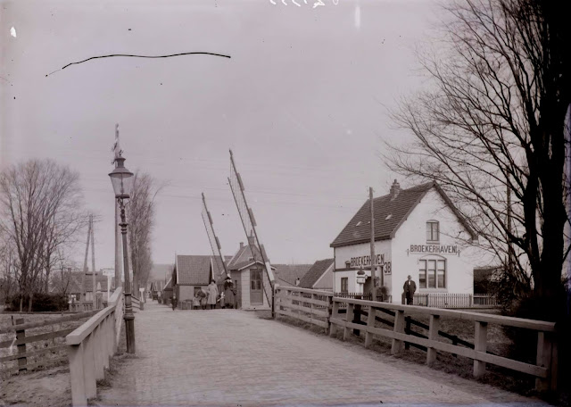
Railway crossing Broekerhaven. © Collectie Rijksdienst voor het Cultureel Erfgoed, BR00883-81355

Oily forwarding mystery - Delft to Port Swettenham via Babo

Newspaper wrapper sent from Delft 17-1-1938 via Pladjoe and Babo to Port Swettenham via Singapore (4-6-1938) The newspaper wrapper shown abo...